Research on Frozen Ground
Kinematics and dynamics of periglacial landforms in western China
Yan Hu, PhD student
Yan is currently working on mapping permafrost landforms in western China, such as rock glaciers, protalus lobes, solifluction sheets etc, and quantifying their kinematic characteristics in order to understand their variations and potential response and impact in the context of global climate change. Her research is based on remote sensing especially InSAR technique and in-situ geological and geophysical investigations.
Watch this 1-min video to get a glimpse of her recent work:
Yan also presented this work at the 5th European Conference on Permafrost (see her poster).
Our collaborators include Professors Lin Zhao and Tonghua Wu (Chinese Academy of Sciences), Professor Tobias Bolch and Dr. Philipp Rastern (University of Zurich), and Dr. Xiaowen Wang (University of Tokyo).
This research is funded by the Hong Kong Research Grants Council (Project CUHK14303417).
Yan is supported by the Hong Kong PhD Fellowship Scheme.
Thermokarst landforms on the Tibetan Plateau
Summer Xia (PhD student) and Lingcao Huang (former postdoc)
This research focuses on the distribution of thermokarst landforms, including thaw slumps (the figure below) and thermal erosion gullies, on the Tibetan Plateau and the factors affecting them. In many permafrost areas, warming and thawing of ground result in distinct thermokarst landforms in remote and isolated regions. He applies image processing methods, including deep learning algorithm, to multi-source remote sensing data, aiming to map these landforms automatically. Wealso analyze the spatial-temporal changes of the mapped landforms and investigates the driving factors of their evolution by integrating other data such as digital elevation model and meteorological data.
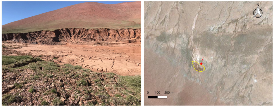
Left: Ground photo of a thaw slump in Beiluhe, Tibet; Right: Planet CubeSat image © 2018 Planet Labs Inc. The yellow line outlines the thaw slump, and the red arrow indicates the position and looking direction of the ground photo.
This research is funded by the Hong Kong Research Grants Council (Projects CUHK14300815 and CUHK14303119).
GNSS Reflectometry and its applications in Cryosphere
Jiahua Zhang, PhD student
Jiahua is working on using the GNSS Interferometric Reflectometry (GNSS-IR) to measure and quantify the changes of ground surface physical properties, such as surface elevation, snow depth, and surface soil moisture, in permafrost terrain, to understand the dynamics of the active layer and the uppermost permafrost, the interactions between them and the atmosphere, and their response to the climate variations.
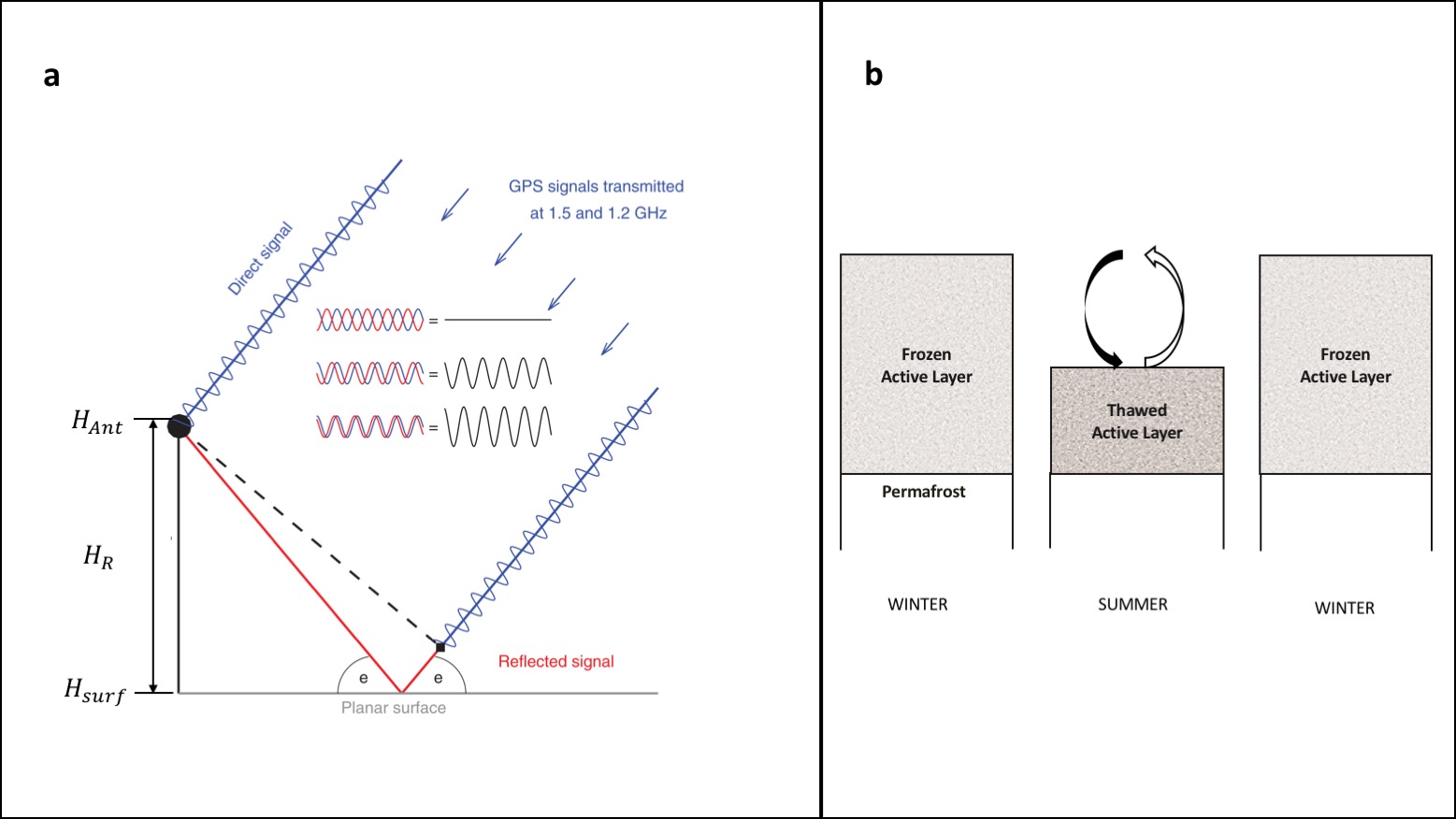
Left: Schematic illustration of GNSS-IR (modified from Larson, 2016), showing the multipath geometry for a horizontal planar and the interference pattern between the direct and reflected signals. HAnt and Hsurf represent the height of the antenna and reflecting surface respectively. HR, the vertical distance between HAnt and Hsurf, is one of the key observables of GNSS-IR. Decrease (increase) of HR indicates the uplift (subsidence) of the reflecting surface. Right: The conceptual model of the seasonal vertical deformation (subsidence in summer and uplift in winter) of the ground surface in permafrost terrain. Such vertical deformation is mainly caused by the phase change of soil moisture within the active layer. GNSS-IR is capable of measuring the surface elevation changes at daily intervals continuously.
Please visit Jiahua’s webpage for furture information, data, and list of publications.
This research is funded by the Hong Kong Research Grants Council (Project CUHK14305618).
Radar Remote Sensing of Permafrost Elevation Changes
Jie Chen, Research Assistant
Jie’s research focuses on investigating permafrost surface dynamics by using radar remote sensing and field observations across local and regional scales. He incorporates permafrost thaw subsidence and uplift model into multi-temporal radar interferometry approaches to mapping and quantifying gradual permafrost thaw subsidence and freeze uplift. He is also interested in retrieving soil moisture based on SAR and polarimetric SAR and mitigating its affect on radar interferometry.
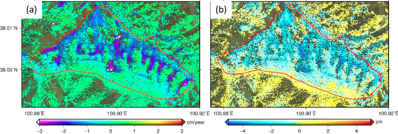
Left: Map of linear subsidence trends in Eboling Mountain, Qinghai-Tibetan Plateau, China. Negative values denote ground subsidence. Right: Map of seasonal subsidence amplitude. The linear subsidence trends are mainly related to the thawing and degradation of the uppermost permafrost. The seasonal subsidence is mainly caused by the volumetric changes of active layer during the freezing and thawing stage.
This research was funded by the Hong Kong Research Grants Council (Project CUHK14300815).