Zhangyu (Joe) Sun is a Ph.D. student of Earth and Environmental Sciences at The Chinese University of Hong Kong. Joe obtained his Bachelor and Master degrees from Wuhan University in 2018 and 2021, respectively. He also has a double-degree Master degree from the Technical University of Munich. He obtained the Hong Kong PhD Fellowship and earned his Ph.D. in 2025. During his Ph.D. study, he used optical remote sensing, InSAR, and deep learning to comprehensively study rock glacier distribution, velocities, and water storage in High Mountain Asia.
Rock glaciers are debris landforms formed by long-term creep of ice-rich permafrost. Their kinematics provide critical insights for climate change and permafrost studies, mountain hydrology, and hazard assessment. Previous studies have measured rock glacier velocities using field-based terrestrial geodetic surveys, repeat photogrammetry, and Interferometric Synthetic Aperture Radar (InSAR). However, these methods have typically been confined to local regions, leaving the large-scale velocity characteristics underexplored. In this study, we developed a multi-temporal and multi-geometry InSAR framework for systematically generating rock glacier velocity fields. We rigorously validated our approach by comparing the InSAR-derived velocities with those derived from very-high-resolution optical imagery (Pléiades satellite imagery and aerial imagery) and Global Navigation Satellite System (GNSS) measurements. The mean relative difference is approximately 20 % when compared to velocities from Pléiades and aerial images, increasing to 50 % for GNSS point measurements. Applying our method, we produced the first large-scale regional rock glacier velocity dataset, encompassing downslope velocity fields for 19,727 previously inventoried rock glaciers in the Tibet-Pamir-Karakoram region. We found a velocity contrast between different climatic domains: rock glaciers in the westerlies domain move on average faster (median = 30 cm/yr) than those in the monsoon domain (median = 13 cm/yr). Our study presents a methodological framework for assessing rock glacier velocities using InSAR and demonstrates its capability for large-scale applications. This approach can be readily adapted to other regions worldwide to support the assessment and monitoring of rock glacier dynamics in a changing climate.
2024
ESSD
TPRoGI: a comprehensive rock glacier inventory for the Tibetan Plateau using deep learning
Zhangyu Sun, Yan Hu, Adina Racoviteanu, Lin Liu, and 6 more authors
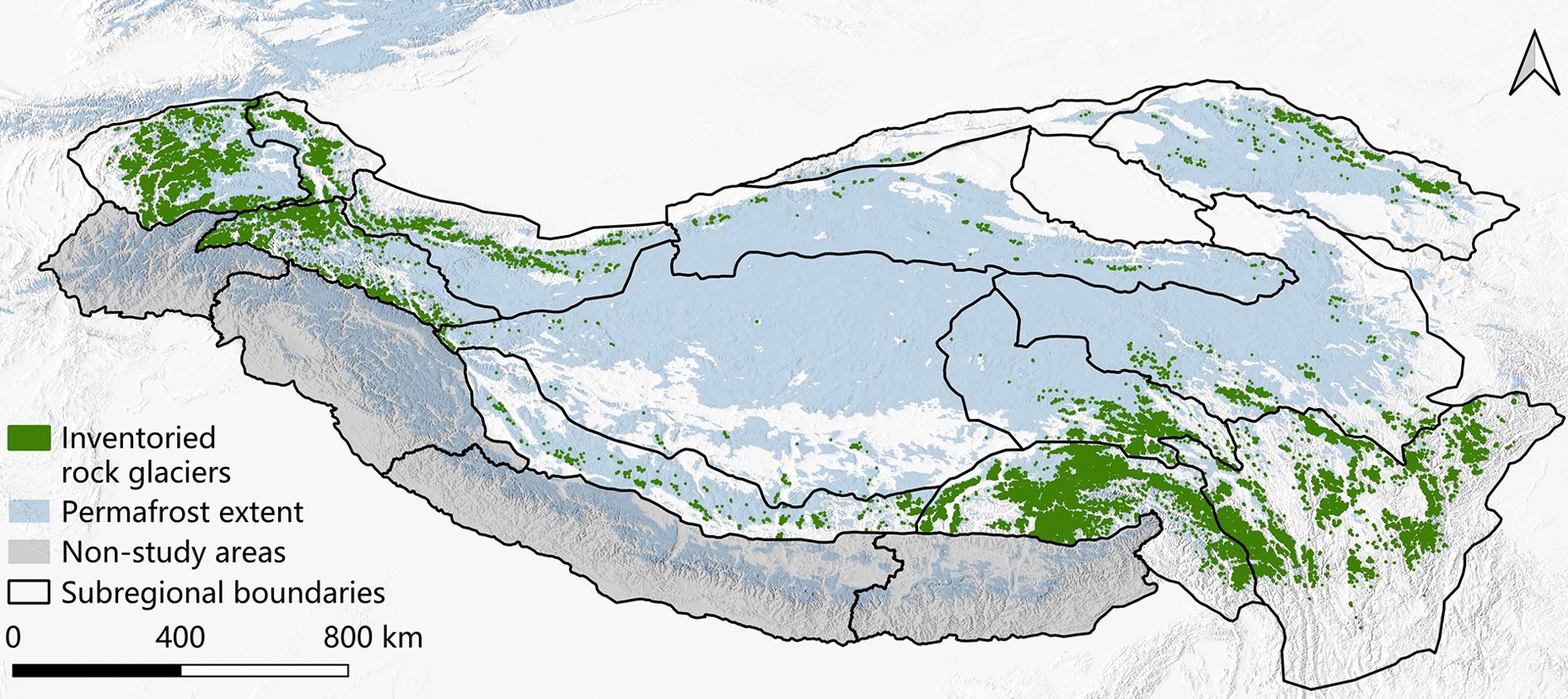
Rock glaciers – periglacial landforms commonly found in high-mountain systems – are of significant scientific value for inferring the presence of permafrost, understanding mountain hydrology, and assessing climate impacts on high-mountain environments. However, inventories remain patchy in many alpine regions, and as a result they are poorly understood for some areas of High Mountain Asia such as the Tibetan Plateau. To address this gap, we compiled a comprehensive inventory of rock glaciers for the Tibetan Plateau, i.e., TPRoGI (v1.0), developed using an innovative deep learning method. This inventory consists of a total of 44 273 rock glaciers, covering approximately 6000 km2, with a mean area of 0.14 km2. They are predominantly situated at elevations ranging from 4000 to 5500 m a.s.l., with a mean of 4729 m a.s.l. They tend to occur on slopes with gradients between 10 and 25\,^∘, with a mean of 17.7\,^∘. Across the plateau, rock glaciers are widespread in the northwestern and southeastern areas, with dense concentrations in the Western Pamir and Nyainqêntanglha, while they are sparsely distributed in the inner part. Our inventory serves as a benchmark dataset, which will be further maintained and updated in the future. This dataset constitutes a significant contribution towards understanding, future monitoring, and assessment of permafrost on the Tibetan Plateau in the context of climate change.